
Uganda: Some Facts and Figures
Area: 91,041 square miles. Similar in size to Britain.
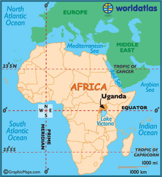
Location: Uganda straddles the Equator. It’s bordered by Kenya to the east; the Democratic Republic of Congo to the west; Rwanda and Tanzania to the south and South Sudan to the north.


| Population: | 30 million |
| Capital: | Kampala – population 1.7m |
| Other major towns: | Jinja1; Mbale, Entebbe and Gulu. |
| Time zone: | GMT +3 |
| Altitude: | 85% of the country is between 900m and 1,500m above sea level. |
| Highest Point: | Mount Stanley in the Rwenzori Mountains (5,110m) |
| Language: | 33 indigenous languages2 are spoken. Lugandan is the most common but English is the official language. |
| Currency: | Uganda shilling |
| Life expectancy: | 54 years (Unicef 2010) |
| Population orphaned by AIDS: | 1.5m |
| Adult literacy: | 65% |
| Land use3: | 43% arable/pasture/agriculture; 28% forest; 4% marsh; 7% other. |
| Main Exports: | coffee; fish; tea; tobacco. |
| Climate: | Daily maximum for most of country 20 – 27 degrees; Daily minimum 12 – 18 degrees. |
| Rainfall: | varies but wet seasons are mid-September to November and March to May |
| Sport: | Football is the most popular sport4. |
1: Jinja is close to the official source of the River Nile at the Owen Falls Dam
2: The language of Karimojong, spoken in the north-east, has a vocabulary of just 180 words!
3: 18% is covered by water – much of that is Lake Victoria, the largest lake in Africa and the second biggest fresh water lake in the world
4: The national team are known as the Cranes – a reference to Uganda’s national bird